
%20-%20Copy.jpg)
Take a look at this map of North Cambridge from the late 1950s. We've used it to indicate all the Arbury-named locations we could find in the city and its environs, past and present. Most of the locations are north of Arbury Road in the fields by the Arbury Iron Age settlement or fort, once known as the Arbury Meadows. This area, with the fields south of Arbury Road, is historically the most Arbury area in Cambridge - and, for new readers, not King's Hedges at all, not even King's Hedges School. Importing the 'King's Hedges' name into the historic Arbury area was, apparently, the council planners' whim of the 1960s and 1970s.
Read all about the real King's Hedges here.
 A mention of Arbury Camp in the 'Weekly Dispatch', March, 1859: Note the spelling of Wandlebury as 'Vandlebury'! For many years, archaeologists believed that, whilst Wandlebury was undoubtedly a fort, Arbury was an undefended settlement with huts and animal enclosures, the iron age equivalent of a village. Recent excavations have led to new thinking on that subject. Arbury Fort or Arbury village? Part of the earthwork outline is clearly marked at Orchard Park (originally Arbury Park and, before that, Arbury Camp Farm) and is called Ring Fort Road.

%20-%20Copy.JPEG)

 From the 'Cambridge Chronicle', 1891: Arbury Terrace for sale - with details of the accommodation offered within the houses there.
%20-%20Copy.jpg)
.jpg) Francis & Son's shop in Arbury Terrace in the early 20th Century. The transition from houses to commercial outlets had begun. Photo: Cambridgeshire Collection.
Francis & Son's shop in Arbury Terrace in the early 20th Century. The transition from houses to commercial outlets had begun. Photo: Cambridgeshire Collection.
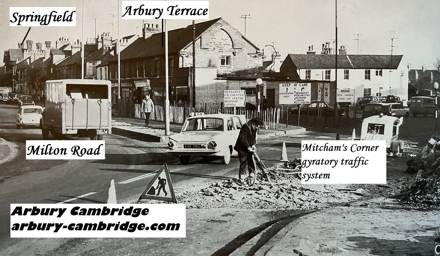
 Another hat tip to Jim Smith, who discovered this Cambridgeshire Collection photograph in Mike Petty's 'Memory Lane' book. The changing face of Arbury Terrace: the late 1960s, and the name had long been lost - all the houses had become commercial outlets. We've marked on some details, including Springfield, the large Victorian house after which Springfield Road and Terrace were named. It was demolished in the early 1970s. Going off at a brief tangent, Andy recalls: 'There was something about that house which gave me the creeps when I was a child! I think it was because of the tall chimneys and the fact it was rather crowded in by surrounding buildings. The lower, terraced properties immediately to its right gave it a rather "looming" presence. Perhaps it needed a country setting. My grandmother said it was once used as St Luke's Vicarage, although I have discovered it wasn't built for that purpose, and there was a soup kitchen at the house in World War 1.' Photo: Cambridgeshire Collection.
The Arbury name is derived from the ancient earthwork at Arbury Camp, the oldest human landmark in the area. In the Arbury Meadows/Furlongs/Corner beside it (see map at top of post) were found many iron age and Roman structures and artefacts (more were discovered last year, including a plesiosaur bone - once in the possession of an Arbury Roman resident!), marking an historic area, with roots pre-dating Chesterton by centuries. The fields south of Arbury Road were also rich in Roman finds, and the Roman Akeman Street/Mere Way crossed the area. Carlton Way follows the route. Part of the road in South Arbury is actually called Mere Way.
Arbury Road is the only road name in Cambridge city with prehistoric links.
In the 1800s, due to its proximity to Cambridge, Chesterton habitations boomed well beyond the village, giving rise to the name 'New Chesterton'. At this time, interest in Arbury Camp was growing.
And a couple of properties named Arbury appeared in New Chesterton.

In May 1872, Mr Clayton, a stonemason, advertised in the Cambridge Independent Press for an apprentice for his business - applications to Arbury House, Chesterton Road.

A few years later, a terrace of houses near the corner of Milton Road and Chesterton Road was built and named 'Arbury Terrace'. Jim Smith, another local history researcher and a contributor to the Arbury Cambridge site, discovered that the name was actually featured on an 1886 Ordnance Survey map.
Robert Clayton, stonemason, lived at No 1 Arbury Terrace during the 1880s. We would be interested to know more about this gentleman. Is this the Mr Clayton, stonemason, of Arbury House in Chesterton Road? It seems almost certain - but we take nothing for granted here!
We've assembled some Arbury Terrace artefacts below.
%20-%20Copy.JPEG)
From the 1886 Ordnance Survey map. Part of Chesterton Road and the houses now marooned on the Mitcham's Corner traffic system island can be seen bottom right, on the corner of Milton Road. Scale's Hotel, to the left, is the site of the Portland Arms public house. Arbury Terrace is featured - with its name - on the map. Photo: Jim Smith.

Jim Smith sent us this photograph of pages from the 1887 Cambridge Street Directory featuring Milton Road and Arbury Terrace.

%20-%20Copy.jpg)
A Cambridgeshire Collection photograph of the corner of Milton Road, with Arbury Terrace on the right. The houses now marooned on the traffic island on Chesterton Road were originally on the corner of Milton Road, until the construction of the 1960s Mitcham's Corner gyratory traffic system.
.jpg)

Comments
Post a Comment