

Was a Roman villa found at King's Hedges? I recently saw an outside display in North Arbury/King's Hedges Ward called 'The Roman Landscape in King's Hedges' which claims there was one. And is King's Hedges Road Roman?
We've seen that display. Electoral wards are not historic areas and local historians really do need to be mindful of that fact.
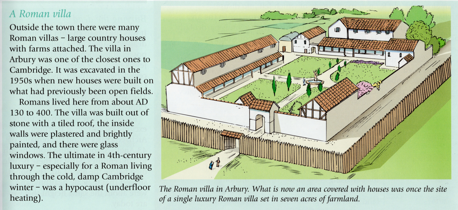
The answer to your questions regarding the Roman villa and King's Hedges Road is no. The Roman villa was found on the site of King's Hedges School, which is not part of the historic King's Hedges acres. Historically, King's Hedges was simply a named property, a farm, of fifty eight acres, and is now north of the guided busway. It was never a district.
King's Hedges School is dearly loved by many of us and we treasure it, but those in the know accept it's not actually in any historically meaningful King's Hedges district, and the site it was built on had nothing to do with King's Hedges. The school was named by the council in 1968, which then had a bit of an obsession with the name. King's Hedges School pupils and teachers made many contributions to the Arbury 1980 project and the 1981 Arbury Is Where We Live! book.
'Kinges Headge' was named by local manorial landowner Richard Brakyn, first appearing in print in 1588. The name points to a royal hedged hunting warren, used to trap and kill animals for 'sport' in the days of the old Royal Manor of Chesterton. These were the 'King's Hedges' and the king would watch the sport from his royal box. The 'sporting' use of the site was also current in the early 1800s - with local pugilists slugging it out - for the 'enjoyment' of Town and Gown.
Take a look at our map below. The Roman villa was not at King's Hedges.


The King's Hedges Estate is purely a product of mid-to-late 20th Century council planners' imaginations and the 'King's Hedges' name has no historical weight in that area, which is also, and far more appropriately, known as North Arbury.
What is particularly vexing about this is the way planners and local councils ignore the work put in by historian Sallie Purkis and the local community in the early 1980s for Arbury 1980 and the Arbury Is Where We Live! book, and wilfully rewrite history with no regard for that work.
If the work had been carried out by people in a more affluent area of the city, we daresay it would still be fawned over to this day - and seen as important. But in an area like Arbury - it seems to be a matter of ignoring the historical truth uncovered by the local (largely working class) community, and forking out for what is actually nonsense - like the display below.
We do hope that we, the public, are not paying for misinformation on outside - or other - displays like this.

%20-%20Copy%20-%20Copy.jpg)
For your final question, no King's Hedges Road is not Roman. It was originally a dead end farm track, leading to the original King's Hedges (see map at the top of this blog post). The majority of King's Hedges Road dates from the late 1970s, when it was redirected and extended across the old Arbury/Harborough Meadows as part of the Cambridge Northern Bypass/A14 development. The new road actually lopped off the end of the original Arbury Road, and is actually on a totally different course to the original King's Hedges Road.
If it was King's Hedges it would be, without protest, query, or old maps and documents saying otherwise.
We love to receive your emails, but please remember we are not the only ones producing local history work and we have nothing to do with anybody who proclaims King's Hedges as anything other than King's Hedges historically. We know there is a 'King's Hedges Estate' Arbury sub-district on the old Arbury Meadows, created by council planners in the 1960s, 1970s and 1980s, and we love King's Hedges School, but historically the name is meaningless in that location.
We spend so much time on the subject answering puzzled enquirers, yet we don't even find the history of King's Hedges very appealing. Hedged hunting warrens for royal entertainment and 'sport' and vast 1970s road extensions really do not interest us much.

The majority of King's Hedges Road appeared in the late 1970s, across the old Harborough/Arbury Meadows by the Arbury iron age camp - and lopped off the original end of Arbury Road.
I saw the 'The Roman Landscape in King's Hedges' board on a bike ride. The producers should be really embarrassed. All the old maps show exactly where King's Hedges was and everybody knows about the petrol guzzlers' King's Hedges Road extension in the '70s. Some of these 'researchers' shouldn't be let out, it's misinformation, plain and simple on their part. King's Hedges is such a gut guzzling pig for sucking up other historic areas.
ReplyDeleteKing's Hedges is largely nonsense, sadly.
DeleteTo make matters worse, a reporter fresh out of University wrote a Cambridge Live article based on that thing!
ReplyDeleteIt's funny calling Arbury Kings Hedges. It's a bit like calling a cat a dog, complete pottiness!
ReplyDeleteThe council need to leave out this Kings Hedges stuff. It's brainwashing and as soon as you take a look through the archives you discover it's poop. The Roman habitation, including this villa, was mainly found near the Arbury Camp and in South Arbury.
ReplyDeleteThe name of King's Hedges School is fine. The only trouble is, it's in an area that historically wasn't King's Hedges and should not be portrayed as if it was. The area by Arbury Camp (North Arbury/King's Hedges Ward) is saturated in references to the earthwork, which is historically of far more note than the acres north of the busway that were the original King's Hedges. If people are to appreciate and identify meaningful with local history it has to be accurate.
ReplyDeleteQuite frankly my dear who gives a damn? Arbury, like the rest of Cambridge, is filling up with non-thinkers, the type of people who have the attention span of gnats, and like to lecture in a highly priggish manner. I was talking to a man in Arbury Court yesterday who banged on about the climate scenario, while having 4 kids, a car and all mod cons. He cycles to work when the weather is nice because it's his duty to the planet. If the Council told him historic Arbury was Bognor Regis, he'd go along.
ReplyDeleteKing's Hedges was such a grotty insignificant plot. Whatever possessed the planners? Too much booze on public expense accounts I reckon.
ReplyDeleteI can't get over most of Kings Hedges Road being '70s. I thought it was the decade of green activism and they go and do that! I was talking to a dude who said that Arbury is now much nearer the city centre than when it was built. It isn't. The city boundary is just where it was then.
ReplyDeleteThe Council can call council estates what they want (they do anyway) but rewriting the history of an area is arrogant and misleading. Typical Cambridge City Council.
ReplyDeleteI don't think most working class people give a fig about the council and its wards or what it calls areas. I live in Chesterton in Laxton Way and to me Arbury starts just past the Golden Hind in Kings Hedges Road. I agree with the point somebody made about Chesterton Community College on here a while back though. I live in Chesterton. That's nearly in Arbury.
ReplyDeleteWhat's truly horrible is the gory hunting connections of Kings Hedges. That is revolting.
ReplyDeleteWere 34 acres of the original King's Hedges originally named Albrach? I keep finding references leading back to a 1980s Cambridgeshire Collection submission, which even wrongly named Impington Park. That submission has been echoed by the Victoria Histories, British History Online, (both of which use local studies units at libraries which can contain incorrect research,. It's in the Cambridge City Council North Cambridge Plan, and council planners have even named a street 'Albrach Court' - and it isn't even part of the original King's Hedges acres. But the name appears nowhere in ANY ancient documents or maps I have examined of the area. There is nothing about Richard Brackyn renaming something called Albrach King's Hedges in 1588. It's not linguistically likely for the language of the time, and sounds like a breakfast cereal!
ReplyDeleteYes, we have come across that submission, and we can't find Albrach either. It might be a wrongly-read reference to Arbury, as the earthwork had been a feature of the area for around one 1,300 years before the 'Albrach' reference, and the Arbury name was evolving. Old maps can be hard to read. We confess ourselves puzzled, but doubtful. We can't add 'Albrach' to our Archive information as we do depend on watertight references and we have none, despite extensive studies of old documents, maps, and running an AI search, which led back to the information being quoted in Victoria Histories, British Histories Online, etc, which led back to the 1980s Cambridgeshire Collection submission. There is nothing any more historical than that. We have recently put out a couple of calls for help on the subject, so we live in hope. But until then Albrach remains apocryphal.
Delete