
1986: Mrs Wiles Remembers Old Arbury and Chesterton: Part 3

1908: The Park Pasture at Manor Farm (later the site of the Manor School) was the scene for this happy wedding photograph, taken by Starr and Rignall Photographers of Cambridge and Ely - Thomas Walter Ashman and Louisa Brett were the happy couple. I have marked on the names of the main family members (the bride and groom are self explanatory!) - all who feature in Mrs Wiles's recollections. One of the Manor Farmhouse ('Manor House') chimneys can be seen in the background. Lydia Prevett was then in service there. She was a bridesmaid at the wedding and married Henry 'Harry' Brett in 1910.

The third part of Mrs Muriel Wiles's memories of the Arbury and Chesterton district during her youth. Mrs Wiles (1909-1987) contributed these recollections to the Arbury Archive in 1986

'Mum and Dad met while Mum was working in Newmarket,' said Mrs Wiles. 'Dad would often cycle all the way from Newmarket to Arbury to visit Mum at Manor Farm.

'Mum said Gran and Grandad were very taken with Dad, and soon a wedding date was set - the 12th of September, 1908. That was my parents' wedding day. 

'The day brought what Mum always called "real heat wave weather" and the jellies wouldn't set!'

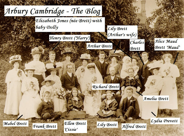
Brett relatives from Histon and Impington and the Ashman relatives of Walter, together with many friends and well-wishers, converged on Manor Farm after the ceremony at St Andrew's Church in Chesterton for the wedding reception. Jellies or not, there was a grand spread and Richard and Amelia had booked Starr and Rignall to take some photographs in the Park meadow at Manor Farm.

'They looked as if they owned the Earth, in the photograph. But they didn't. Grandad was a very hard worker and kept the family in as much comfort as he could,' said Mrs Wiles in 1986, looking at the main wedding group photograph which hung on the wall in her back room at Springfield Terrace. 

'My mother often looked at the photo and said how lovely the fashions were, and then she'd sigh because hemlines had come up and the hats had gone. When I was a little girl, I looked at it and said: "Mum, why are those ladies wearing cakes on their heads?" Mum was taken aback, but that's just what those hats looked liked to me!

We're hoping to build this 1920s map of the Arbury/New Chesterton district up into a handy reference to all the locations mentioned by Mrs Wiles during this series. Note the locations of her cousins' and the Bretts' houses, her father's allotment, her uncle's smallholding, the Roman road, and the Arbury, Arbury Field and 'Boy's Pit' fields at Manor Farm.

'Mum felt tired out as her wedding day wore on. There had been a lot of heat, rich food, hand shaking, guests and it was all a bit much really. She popped upstairs at one point "just to fetch something" - but the sight of her old bed was too much for her. She eased off her shoes and, being careful not to crease her wedding dress, laid herself down. She'd just have a minute's rest, she thought.

'Well, downstairs, Dad was tired out too. There were guests all around the farmhouse and in the garden as the stars came out to twinkle, and he sat himself down in the parlour in an armchair to wait for Mum to come back down.

'And they both fell asleep. Well, of course, nobody had the heart to wake them, and when they did wake up, it was the next day! Mum often told us the story of her wedding day over the years - and what a wedding night! We did laugh!

Mrs Wiles in her back garden at Springfield Terrace in 1985. She was a keen gardener, although she wished that her garden was wider. The gardens in the Terrace always seemed amazingly narrow to Andy.

'It was lovely when I was young because I had cousin Grace living just up on Milton Road and cousin Reg on the corner of George Street. We often went up to Uncle Harry's smallholding at Manor Farm. "Chase Through The Artichokes" was a favourite game there!

'Mum told me that the Park meadow at Manor Farm had been much bigger when she was a girl. The Council chopped part of it up for smallholdings, including Uncle Harry's. Two of the big fields of the farm survived the sale - Arbury and Arbury Field - because some people had big smallholdings - like Mr Camps who lived next door to the Sales at the top of the Drive by Arbury Road. There was a smaller field a bit further up than them, by the water course near where Grandad had his ground. It was called "Boy's Pit". It was called that, so Mum said, because a boy had drowned there many years ago. She didn't know who, and neither did anybody else I asked. His name was long forgotten.

'Boy's Pit... it was.... well, it was a creepy thing to call it really, although it was done as a remembrance. But I still had a lot of happy times playing there with Grace and Reg and George Wright.

'One day, I was up there on my own and suddenly the sun went in and the water turned from blue to dark grey and it looked... well... quite sinister! I went back to the farmhouse to Gran as quick as I could. Isn't it funny how weather changes the mood of a place? I've often thought that.'

A postcard from Portsmouth to Mrs Wiles (then aged ten) at Springfield Terrace, dated 20 July 1921. This was from her Aunt Lydia, wife of Harry [Henry] Brett and mother of Grace. Lydia had gone to work for Mr and Mrs Pepper at Manor Farm as a young woman, and Mrs Pepper had bestowed on her the name 'Annie' (names like Lydia were often not deemed 'appropriate' for servants by their mistresses) and this name rather stuck. Mrs Wiles always spoke of her as 'Aunt Annie'. Note the tilted stamp denoted an extra kiss to go with the x's. The family did not use phrases like 'most ripping' or 'simply lovely' in speech!

Dear Muriel,

Just a card to say I am having  a most ripping time. It is simply lovely here. I've been in the sea to bathe in a bathing costume. Has Uncle Harry shown you the photo of us in the sea? It was great fun. Have you seen Grace? I have not had a line yet from Uncle Harry. Fond love to all, Auntie Lydia x x x x x x x x x x x x x x

A straight-backed, sitting posture was considered most important when Mrs Wiles was attending Milton Road School. 

'I remember us all sitting there with our arms folded behind our backs! Not that we were always so well behaved. Me and Grace scratched our initials into the privy wall here [at Springfield Terrace] and into the wall leading into the Terrace. A lot of kiddies did the same! Funny really... I suppose it was for posterity or something!'

We went out to look at the wall in the 1980s to see if we could find the 'G.B.' and 'M.A.' initials, but several generations had been at work since then!

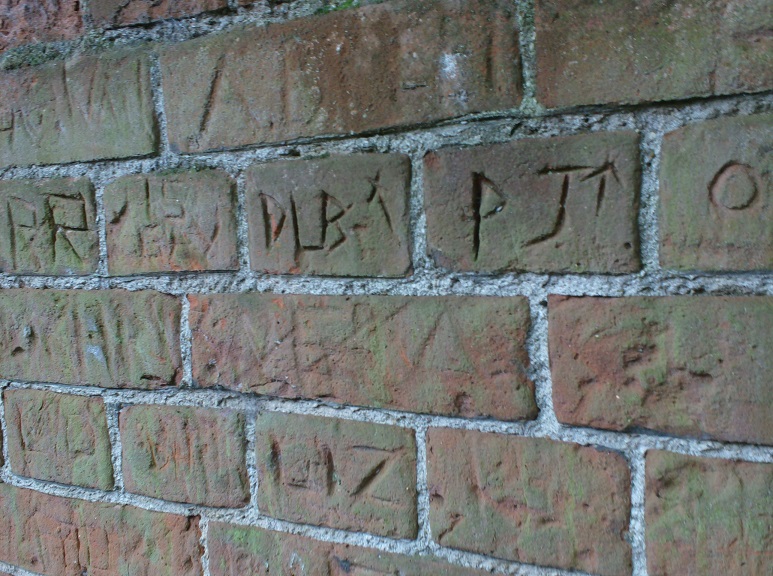
The wall leading into Springfield Terrace in more recent years.

Part 4 of Mrs Wiles's memories is here.


Comments

Popular posts from this blog

What Did The Romans Ever Do for Arbury? Jim Smith

Our trusty old Arbury map showing location details before the Manor Farm was established. The red line, inserted by Jim Smith, indicates the course of the Roman road - Akeman Street or the Mere Way. The land north of Arbury Road was the Arbury or Harborough Meadows, Arbury/Harborough furlongs and Arbury Camp, King's Hedges was in its original position, north of the railway (now guided busway) and Arbury Road ran from the Ely/Milton Road to the Histon/Cambridge Road - as it did until the late 1970s. Introduction - by the Arbury Archivists Jim Smith is a local history researcher and a good friend of the Arbury Cambridge Blog. He has been researching Roman finds in the historic Arbury area and has written this article for us. We are most grateful! He follows the adventures of those who scraped away centuries of soil to reveal ancient findings beneath.  Of course, as always, we deal with historic Arbury here, not council planners' estates or electoral wards, which are both prone to

Exploring The REAL King's Hedges...

The Cambridge and St Ives Branch railway line is now the Guided Busway. Where was King's Hedges historically? How did the name come about? Why is the majority of King's Hedges Road no more historic than late 1970s - and nothing to do with the course of the original road? What have council planners of the 1960s and 1970s and the needs of motorists got to do with the King's Hedges presence in the historic Arbury district? All will be revealed... We're going to leave Arbury briefly and go to King's Hedges. No, not King's Hedges Ward - that area is, in reality, one of the most Arbury of Arbury areas in Cambridge historically, but the REAL King's Hedges. North of the Guided Busway. You see, the land north of Arbury Road is the site of the Arbury Camp, the Arbury/Harborough (a variation on the Arbury name) Meadows and the Arbury fields of Manor Farm.  It has absolutely nothing to do with King's Hedges at all. And King's Hedges was never a district. It was

Main Streets of Arbury: Campkin Road - Part 1

Left: work begins on Campkin Road in 1961. Numbers 1 and 2 Manor Farm Cottages have been demolished, but the intention is to preserve the old trees lining the old Manor Farm Drive. Right: a similar view in more modern times, with the Arbury Town Park and Campkin Road. In 1982, Campkin Road was described as the 'Hauptstrasse of North Arbury' by local journalist Sara Payne. Ms Payne's local history articles in the Cambridge Weekly News were hugely popular and, for each one, Ms Payne visited a street in Cambridge and talked to the residents, collecting their memories for publication and producing a fascinating series of 'Then and Now' style articles. 'Cambridge Weekly News', 1982. Down Your Street followed in the footsteps of a similar series in the local press in the early 1960s - by Erica Dimmock - and both now make fascinating reading. We're starting our look at Campkin Road with material from the 'Arbury 1980' project and accounts from locals

Manor School Memories Part 1

The Manor School on Arbury Road was one of the main focuses of life for North and South Arbury for decades. With its evening classes and youth centre, and various community activities - like the annual Christmas party for the elderly and the annual school play in the 1980s ( Annie Get Your Gun and Dracula Spectacular spring to mind) - the Manor opened as separate boys' and girls' schools in 1959 (the girls had to share the boys' buildings at first as their own were still under construction). The school later became co-ed.      An aerial view of t he Manor Schools - Boys' and Girls', around 1960, with a section of Arbury Road and Arbury Court. Note Arbury Court was yet to gain its library and large supermarket building, and Campkin Road was still the Manor Farm Drive. The side of the Manor School 'new block', built in the early 1970s, the tower block and boys' gym beyond. The school was built in the Park Meadow of the old Manor Farm - which is how the &

Arbury Court - Part Of The 'Centre' Of The Original Arbury Estate...

A view across Arbury Court, looking towards Arbury Road, in 1976. Arbury Court is part of the 'centre' of the original Arbury Estate in Cambridge. The Court, with its pub, supermarket, hardware store and post office, chip shop, newsagent, TV shop, greengrocer, hairdresser, chemist, supermarket and branch library, is part of the 'hub' of the estate. The historic Arbury district. The Arbury or Harborough (the names were variations on each other and interchangeable) Meadows covered most of the land north of Arbury Road. The road ran from Milton Road to the Histon/Cambridge Road until the late 1970s. The Manor Farm was formed in the years following the 1840 Chesterton Enclosures. Orchard Park (originally Arbury Park and, before that, Arbury Camp Farm) features the outline of part of the Arbury prehistoric settlement at Ring Fort Road. We've inserted the sites of Arbury Court, the Guided Busway and Campkin Road. Arbury Road marks the boundary of North and South Arbury, a

Arbury Archaeology and History: Part 1

Imagine an iron age settlement. It is surrounded by a circular earthwork. People live here. There are houses, and pens for animals within the enclosure. Until recent years, it was not believed to be a fort. The settlement is larger than some, but believed to be very much the equivalent of what we now call a village - the earthwork simply to defend it from wolves and animal thieves. The earthwork is filled with water, and reeds and rushes grow there. Despite the naming of the Arbury earthwork as 'Ring Fort Road' in the Arbury Camp Farm Arbury/Orchard Park development, the original height of the earthwork and its enclosed area were not believed to indicate that Arbury was a fort (compare to Wandlebury), and the findings of archaeologists from Cambridge and London from the early 1960s to 1970 discounted the notion. Comment from Arbury Camp, Cambridge, A Preliminary Report on Excavations - by John Alexander and David Trump, 1970: The excavations therefore tend to confirm earlier s

Ask Arbury: The Roman Villa in Arbury

     E-mail to Arbury Cambridge blog: Was a Roman villa found at King's Hedges? I recently saw an outside display in North Arbury/King's Hedges Ward called 'The Roman Landscape in King's Hedges' which claims there was one. And is King's Hedges Road Roman?  We've seen that display. Electoral wards are not historic areas and local historians really do need to be mindful of that fact. The answer to your questions regarding the Roman villa and King's Hedges Road is no. The Roman villa was found on the site of King's Hedges School, which is not part of the historic King's Hedges acres. Historically, King's Hedges was simply a named property, a farm, of fifty eight acres, and is now north of the guided busway. It was never a district. King's Hedges School is dearly loved by many of us and we treasure it, but those in the know accept it's not actually in any historically meaningful King's Hedges district, and the site it was built on ha

Manor School Memories - Part 2

Lads from the Manor Boys' School in 1960. D. Claton, M. Farrow, R. Mitchell, C. Peck, I. Skeels, R. Potter and G. Paine are present. Do any readers remember who is who? School's back in - Manor School/Community College on Arbury Road that is (now North Cambridge Academy). Here is the second part of our series on Manor Memories - Part 1 is here . Pupils' foreign holiday, 1960: the first Manor girls to go on a joint foreign holiday with Manor boys: G. Anderson, J. Barnes, C. Blackwell, H. Brown, S. Budd, L. Carter, A. Clarke, L. Doggett, C. Doughty, P. Drake, S. Hardy, E. Harradine, B. Kaspar, D. Miller, J. Parker, L. Phillips, J. Reeves, J. Spencer, J. Symonds, with headmistress Mrs Firman. Note the Manor Schools' caretaker's house can be seen in the background, and the trees of the old Manor Farm orchard. October 1960, and here is a view of the Manor Boys' and Girls' schools from the car park at the Snow Cat public house (now the Cambridge Gurdwara). A view

What Arbury Means To You...

We thought it would be good to invite comments (or emails - arburyestate@btinternet.com) from readers about what Arbury means to you. Of course, many have already made their views plain on here, but we like the idea of a dedicated blog post. Please be aware that we are referring to the original Arbury area here, the area between Gilbert Road and King's Hedges Road, not modern electoral wards/misnamed apparently 'separate' housing estates. From 'Arbury is Where We Live!' (1981): Community action has always been important in Arbury. The first Arbury community groups were formed with the building of South Arbury in the 1950s, and North Arbury has seen many fantastic community efforts - resulting in the likes of the Arbury Adventure Playground, Arbury Carnival, Arbury Community Centre and the Arbury Town Park. So, what does Arbury mean to YOU? How long have you lived here? Are you interested in Arbury history? What do you like about Arbury? What do you dislike? What mak

Arbury Snippets Part 4: Arbury Terrace, Arbury Hedges, 19th Century Pugilists, Hunting & Escaped Prisoners At The Real King's Hedges And Suspects On The Arbury Meadows...

We've superimposed the old Arbury Meadows, Furlongs and Corner onto a 1900 map. Remember, the Manor Farm, which covered most of North Arbury (or the Council's inappropriately named 'King's Hedges Ward'), did not exist before the 1840s. Our 1900 map also features the details from the 1840 enclosures map. The names Arbury and Harborough were variations on each other and interchangeable. Whilst the 1840 enclosures map used the 'Harborough' form, an 1839 newspaper article (featured) used the 'Arbury' form. During the late 1800s, the 'Harborough' form all but disappeared. The Arbury name is derived from the Old English for 'earthwork', the earthwork surrounding the iron age settlement at Arbury Camp Farm (now Orchard Park, originally Arbury Park). The earthwork, or at least part of it, was a landscape feature for around 2000 years, and the part of the outline seen on this map is incorporated into the design of Ring Fort Road. Arbury was. f