
Support the Arbury Carnival...

Be a hero for the Arbury Carnival...

The emails and phone line here were red hot last Wednesday night as we mounted a whip-round to support the Arbury Carnival. 

The Carnival is so special.

It is a day for the whole of modern Arbury to get together, to have fun and be friends and neighbours, and for those 'outside' of Arbury (and the historic Arbury district boundaries are NOT a matter of inaccurately named electoral wards and a modern highway) it's also a time to join in, have fun, be friends and neighbours and so on.

Be a hero - duck in and help!

The Arbury name is very special indeed. Arbury Road is the only road name in Cambridge with prehistoric links, and the ancient human habitation and its surrounding Harborough (a variation of the Arbury name) or Arbury Meadows and Arbury Fields are local history writ plain.

The Arbury Meadows - north of Arbury Road, with the North Arbury Furlong, West Arbury Corner and Arbury Corner. The name is derived from the prehistoric earthwork at Arbury Camp. The red line indicates the course of the Roman road, the Mere Way or Akeman Street. Carlton Way and Mere Way, in South Arbury, follow the course of the road.

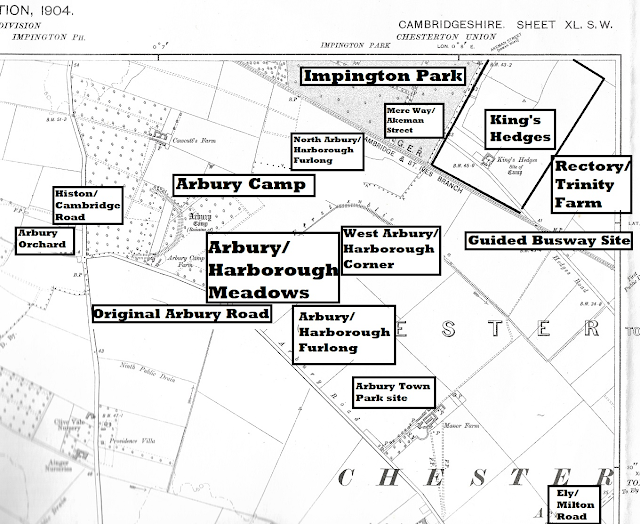
The Carnival is evidence of the strong community spirit of the Arbury Estate, and stretches all the way back to 1977 - the decade when Arbury also established its own adventure playground, Town Park and community centre.

The 1980s, of course, gave us the Arbury 1980 project and the Arbury Is Where We Live! book - which put the Arbury history and accounts of the (then) modern day on record.

The Carnival has made its initial target of £700 and more, but please throw anything into the hat you can afford. The idea is to form a bit of a 'pillow' for future expenses.

Also, please look to the future some more. Help is needed behind the scenes to organise the Carnival so please visit the Arbury Carnival Twitter page. The AGM is on 25 July: https://twitter.com/ArburyCarnival


Arbury is ancient - and modern... The Arbury Carnival site and its historic neighbourhood in the days of the Manor Farm, which occupied much of the old Arbury Meadows and was established in the years following the 1840 Chesterton Enclosures. The 'Arbury' name is a link to something more ancient than Chesterton - the earthwork at Arbury Camp. Part of the outline can still be seen at Ring Fort Road at Orchard Park (originally Arbury Park, and, before that, Arbury Camp Farm).


Comments

Popular posts from this blog

What Did The Romans Ever Do for Arbury? Jim Smith

Our trusty old Arbury map showing location details before the Manor Farm was established. The red line, inserted by Jim Smith, indicates the course of the Roman road - Akeman Street or the Mere Way. The land north of Arbury Road was the Arbury or Harborough Meadows, Arbury/Harborough furlongs and Arbury Camp, King's Hedges was in its original position, north of the railway (now guided busway) and Arbury Road ran from the Ely/Milton Road to the Histon/Cambridge Road - as it did until the late 1970s. Introduction - by the Arbury Archivists Jim Smith is a local history researcher and a good friend of the Arbury Cambridge Blog. He has been researching Roman finds in the historic Arbury area and has written this article for us. We are most grateful! He follows the adventures of those who scraped away centuries of soil to reveal ancient findings beneath.  Of course, as always, we deal with historic Arbury here, not council planners' estates or electoral wards, which are both prone to

Main Streets of Arbury: Campkin Road - Part 1

Left: work begins on Campkin Road in 1961. Numbers 1 and 2 Manor Farm Cottages have been demolished, but the intention is to preserve the old trees lining the old Manor Farm Drive. Right: a similar view in more modern times, with the Arbury Town Park and Campkin Road. In 1982, Campkin Road was described as the 'Hauptstrasse of North Arbury' by local journalist Sara Payne. Ms Payne's   Down Your Street  local history articles in the   Cambridge Weekly News   were hugely popular and, for each one, Ms Payne visited a street in Cambridge and talked to the residents, collecting their memories for publication and producing a fascinating series of 'Then and Now' style articles. Down Your Street  followed in the footsteps of a similar series in the local press in the early 1960s - by Erica Dimmock - and both now make fascinating reading. We're starting our look at Campkin Road with material from the 'Arbury 1980' project and accounts from locals contributed to t

Exploring The REAL King's Hedges...

The Cambridge and St Ives Branch railway line is now the Guided Busway. Where was King's Hedges historically? How did the name come about? Why is the majority of King's Hedges Road no more historic than late 1970s - and nothing to do with the course of the original road? What have council planners of the 1960s and 1970s and the needs of motorists got to do with the King's Hedges presence in the historic Arbury district? All will be revealed... We're going to leave Arbury briefly and go to King's Hedges. No, not King's Hedges Ward - that area is, in reality, one of the most Arbury of Arbury areas in Cambridge historically, but the REAL King's Hedges. North of the Guided Busway. You see, the land north of Arbury Road is the site of the Arbury Camp, the Arbury/Harborough (a variation on the Arbury name) Meadows and the Arbury fields of Manor Farm.  It has absolutely nothing to do with King's Hedges at all. And King's Hedges was never a district. Land no